There is a particular kind of pleasure that comes from truly knowing a place. Not just knowing its name or its general location on a map, but knowing it the way a longtime resident knows it — the back roads that connect unexpected destinations, the hidden waterfront spots that reward those who know where to look, the parks and trails and community gathering places that give a community its genuine character and soul. The Map of Orono is the key to that kind of knowing, and this guide is your complete introduction to everything it reveals.
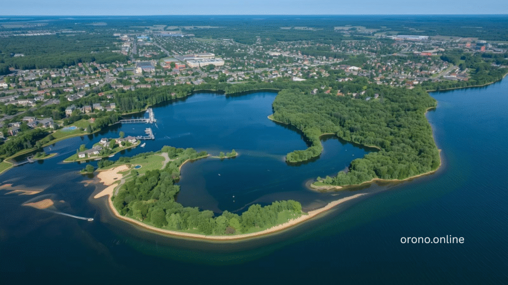
Orono, Minnesota is a community that rewards exploration. Situated along the stunning shores of Lake Minnetonka in western Hennepin County, Orono occupies a geography that is simultaneously beautiful, varied, and full of destinations worth discovering. The Map of Orono encompasses everything from the public beaches and boat launches that provide access to Lake Minnetonka’s extraordinary waters to the quiet residential streets lined with mature trees that give Orono neighborhoods their distinctive and deeply appealing character.
What the Map of Orono reveals to anyone who studies it carefully is a community that has been thoughtfully developed over generations — one that has balanced growth with preservation, accessibility with natural beauty, and community infrastructure with the environmental stewardship that a Lake Minnetonka community demands of itself. The parks, trails, public facilities, waterfront access points, and community gathering places distributed across the Map of Orono are not accidents. They are the accumulated result of deliberate community investment in the quality of life that makes Orono one of the most genuinely desirable communities in the entire Twin Cities metropolitan area.
Whether you are a new Orono resident still learning the community’s geography, a longtime resident who thinks they know every corner but is ready to discover something new, a visitor planning a trip to the Lake Minnetonka area who wants to understand what Orono has to offer, or simply someone who finds that understanding a place’s geography deepens your appreciation for everything it is — this complete guide explores the 15 most amazing places on the Map of Orono that every visitor and resident should know and experience this summer.
Map of Orono at a Glance
| Detail | Information |
|---|---|
| Location | Western Hennepin County, Minnesota |
| Community Type | Suburban Residential City |
| Area | Approximately 14 Square Miles |
| Population | Approximately 8,000 Residents |
| Primary Water Feature | Lake Minnetonka |
| Neighboring Communities | Wayzata, Minnetonka Beach, Long Lake, Mound |
| Government | City Council / Mayor Form |
| School District | Orono School District |
| Natural Features | Lake Minnetonka, Wetlands, Wooded Areas |
| Best Resource | City of Orono Official Website |
1. Lake Minnetonka Shoreline
No exploration of the Map of Orono is complete without beginning at the feature that defines the community more than any other — the Lake Minnetonka shoreline that traces the eastern and southern boundaries of the city and provides the natural backdrop against which all of Orono’s other qualities are experienced.
The Map of Orono along the Lake Minnetonka shoreline reveals a varied and beautiful edge — alternating between public access points, private waterfront properties, natural wetland margins, and the wooded bluffs that create the visual character of the lake’s north shore. Walking or driving sections of this shoreline — even the portions accessible from public roads — provides a perspective on Lake Minnetonka that most visitors never experience.
The Lake Minnetonka shoreline visible on the Map of Orono is not uniform in character. Different sections of the lake edge offer different experiences — calm protected bays, open water exposures with long views across the lake, natural wetland transitions rich with wildlife, and the occasional historic lakeside property that speaks to the long history of this community’s relationship with its defining water feature.
Understanding where the publicly accessible sections of the Lake Minnetonka shoreline fall on the Map of Orono — the beaches, boat launches, and waterfront parks — helps visitors and residents maximize their experience of the lake that makes this community genuinely extraordinary.
2. Orono Public Beaches
The public beaches marked on the Map of Orono represent some of the most beloved and consistently used community destinations available to residents — the spots where summer memories are made, where children learn to swim, and where the relationship between the Orono community and Lake Minnetonka becomes most immediate and personal.
Orono’s public beaches provide sandy shoreline access to Lake Minnetonka with the safety infrastructure, parking, and amenities that make family beach visits practical and enjoyable. Finding these beach locations on the Map of Orono and understanding their individual characteristics — water depth, amenities, parking availability, and seasonal programming — helps residents and visitors choose the right beach for their specific needs and preferences.
The public beaches on the Map of Orono are distributed around different sections of the Lake Minnetonka shoreline, meaning that different beaches offer different orientations, water conditions, and surrounding landscapes. Exploring multiple beach locations across the Map of Orono rewards visitors with the understanding that no single beach captures the full variety of what Orono’s Lake Minnetonka access offers.
3. Public Boat Launches and Water Access Points
For boaters, kayakers, anglers, and water sports enthusiasts, the public boat launches and water access points marked on the Map of Orono are among the most practically important destinations in the entire community — the gateways through which Lake Minnetonka becomes fully accessible rather than something to admire from the shore.
The Map of Orono shows several public water access points around the city’s Lake Minnetonka shoreline, each with its own characteristics in terms of ramp quality, parking capacity, and the specific section of the lake they access. Understanding the differences between these launch points helps boaters select the one best suited to their vessel size, destination on the lake, and tolerance for busy versus quieter conditions.
Water access points on the Map of Orono serve the full range of human-powered watercraft as well as motorized boats — kayakers and canoeists launching from these facilities gain access to some of the most beautiful paddling routes on Lake Minnetonka, particularly in the early morning hours before motorized traffic builds.
4. Orono Parks and Green Spaces
The parks and green spaces distributed across the Map of Orono reflect the community’s consistent investment in the recreational infrastructure and natural areas that contribute to quality of life for residents of all ages throughout the entire year.
Orono parks vary considerably in character — some are active recreational spaces with sports fields, playground equipment, and structured amenities, while others are more naturalistic preserves that protect wetland habitat, woodland, and natural landscape features that contribute to the community’s environmental health and visual character. Understanding this variety through the Map of Orono helps residents find the park experience that best matches their specific recreational preferences.
The green spaces on the Map of Orono collectively create a network of natural areas distributed throughout the community that provides wildlife habitat, stormwater management, recreational access, and the aesthetic quality of a community that values natural open space as a genuine community resource rather than simply unused land awaiting development.
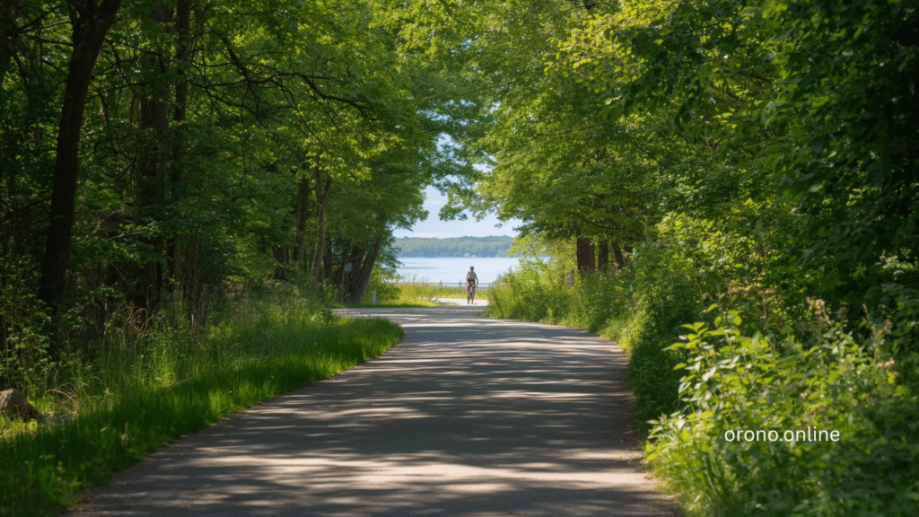
5. Orono Trail System
The trails marked on the Map of Orono connect parks, neighborhoods, water access points, and community destinations through a network of walking and cycling routes that allow residents to experience the community’s natural beauty under their own power rather than through a car window.
Following the trail system on the Map of Orono reveals the full visual variety of Orono’s landscape — the open water views that appear through tree gaps near the Lake Minnetonka shoreline, the quiet wooded sections that feel remarkably removed from suburban life, and the neighborhood streetscape sections that connect community destinations through residential environments that showcase Orono’s distinctive residential character.
The Map of Orono trail connections to the broader Lake Minnetonka Regional Trail network extend the accessible cycling and walking routes available to Orono residents well beyond the city limits — creating routes that traverse multiple Lake Minnetonka communities and provide hours of exploration across varied and consistently beautiful terrain.
6. Orono City Hall and Civic Center
The civic center area visible on the Map of Orono — including City Hall, public works facilities, and associated municipal infrastructure — represents the administrative heart of community governance and the physical location where the day-to-day business of running this exceptional city takes place.
City Hall on the Map of Orono is more than a bureaucratic address — it is where residents engage with local government directly, where public meetings bring community members and elected officials together to make collective decisions, and where the civic life of Orono is formally organized and expressed. Knowing where City Hall falls on the Map of Orono is practical knowledge for any resident who engages with local government.
The civic center area on the Map of Orono is also the location of public information resources — current maps, zoning information, permit offices, and the staff who can direct residents to the services and information they need from city government. First-time visitors to City Hall are consistently surprised by the accessibility and responsiveness of Orono’s municipal staff.
7. Orono Schools Campus
The school campus locations marked on the Map of Orono represent one of the community’s most valued assets — the Orono School District facilities where generations of community children have received the quality education that makes Orono school district enrollment one of the most sought-after in the entire Twin Cities metropolitan area.
Understanding where Orono school campuses fall on the Map of Orono is practical knowledge for families with children in the district — informing decisions about neighborhood selection, understanding school walking and bus route logistics, and providing geographic context for the school-related activities that dominate family schedules throughout the academic year.
The school facilities on the Map of Orono also serve as community gathering spaces beyond school hours — athletic fields, auditoriums, and community rooms that host events, programs, and activities that serve the broader Orono community rather than exclusively the student population.
8. Orono Historical Landmarks
The historical landmarks scattered across the Map of Orono connect the present community to the deep and fascinating history of this Lake Minnetonka area — the Indigenous cultural heritage that preceded European settlement, the early resort and recreational development that made Lake Minnetonka famous across the region in the late nineteenth century, and the subsequent residential development that shaped the community recognizable today.
Exploring historical landmarks on the Map of Orono transforms a drive or walk through the community from a purely present-tense experience into one informed by awareness of the layers of history that each location carries. Properties, roads, and landscape features that seem ordinary gain dimension when understood in their historical context.
The Map of Orono historical resources available through the Orono city website, local historical society, and Hennepin County historical programs provide the narrative context that makes physical landmarks meaningful rather than simply old. Combining map exploration with historical research produces the richest possible understanding of what makes Orono the distinctive community it is today.
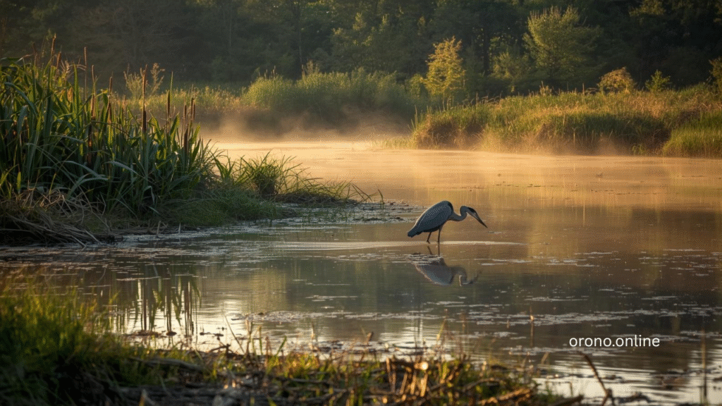
9. Wetland and Natural Area Preserves
The wetland and natural area preserves identified on the Map of Orono represent some of the community’s most ecologically significant and visually beautiful landscapes — protected areas that provide irreplaceable habitat, water quality services, and natural beauty that development would permanently eliminate.
Orono’s position within the Lake Minnetonka watershed means that wetland preservation is not just aesthetically valuable but ecologically essential. The wetlands marked on the Map of Orono filter stormwater, capture nutrients before they reach the lake, provide nesting and foraging habitat for waterfowl and shorebirds, and maintain the natural hydrology that sustains the broader ecological system surrounding Lake Minnetonka.
Visiting accessible natural areas and preserves on the Map of Orono reveals a dimension of the community that manicured residential landscapes and developed parks do not provide — the experience of genuinely wild natural space within easy reach of one of the Twin Cities’ most desirable residential communities. Patient observation in these areas consistently rewards visitors with wildlife encounters that feel genuinely extraordinary.
10. Grays Bay and Connected Bays
The Grays Bay area and the other distinct bays within the Orono section of Lake Minnetonka are among the most geographically interesting features on the Map of Orono — protected water bodies with their own ecological character, recreational quality, and community significance that differ meaningfully from the open lake sections accessible from other positions around the shoreline.
Grays Bay on the Map of Orono provides calmer, more protected water conditions than fully exposed lake sections — conditions that are particularly valuable for families with young children, beginning boaters, and kayakers who prefer to start their water exploration in gentler circumstances before venturing into open lake conditions.
The bay areas visible on the Map of Orono also support some of the richest wildlife habitat accessible from the city’s waterfront — the transition zones between open water, shallow bay margins, and wetland vegetation that herons, loons, eagles, and waterfowl use extensively throughout the summer season.
11. Orono Neighborhood Districts
The distinct neighborhood areas visible on the Map of Orono — each with its own character, landscape quality, housing stock, and community feel — collectively create the residential variety that gives Orono its depth as a community and makes different sections of the map appeal differently to different residents and visitors.
Some neighborhoods on the Map of Orono sit directly on the Lake Minnetonka shoreline, with the lake visible from residential streets and the water accessible within walking distance of virtually every home. Others occupy the rolling wooded terrain farther from the lake — quieter, more private, and characterized by the mature tree canopy that creates Orono’s most distinctive residential landscape quality.
Understanding the neighborhood geography of the Map of Orono helps prospective residents evaluate community fit during the home search process — identifying the sections of the map where the balance of lake access, privacy, community character, and commute logistics best matches their specific priorities and lifestyle preferences.
12. Long Lake Area
The Long Lake area visible on the Map of Orono represents one of the community’s most charming geographic features — a secondary lake body that provides additional waterfront character, recreational access, and natural beauty to the sections of Orono that border it.
Long Lake on the Map of Orono offers a quieter, more intimate water experience than the expansive Lake Minnetonka system — conditions that suit residents and visitors seeking peaceful paddling, fishing, or simply the visual pleasure of a natural lake in a beautiful residential setting without the boat traffic that Lake Minnetonka’s popularity generates.
The Long Lake area on the Map of Orono demonstrates the geographic generosity of a community that offers not one but multiple natural water features to residents and visitors — each with its own character and recreational possibilities that reward exploration and return visits throughout the season.
13. Maxwell Bay Area
The Maxwell Bay section of the Map of Orono represents one of the most visited and practically significant waterfront areas in the community — home to the Maxwell Bay Boat Launch and the associated recreational infrastructure that provides public access to Lake Minnetonka for boaters, anglers, and water enthusiasts.
Understanding the Maxwell Bay area on the Map of Orono — its position within the Lake Minnetonka system, the facilities available there, and the specific section of the lake it accesses — is practical knowledge for any Orono resident or visitor planning water-based recreation on Lake Minnetonka.
The Maxwell Bay area on the Map of Orono also represents one of the most visually beautiful sections of the community’s Lake Minnetonka shoreline — a location where the combination of wooded shoreline, open water, and the particular light conditions of the north shore creates photographic and recreational opportunities that reward repeat visits throughout the season.
14. Orono’s Connection to Regional Trail Networks
The points where Orono’s local trail system connects to regional trail networks — visible as key nodes on the Map of Orono — represent some of the most strategically valuable locations for residents who use cycling and walking as primary recreational or commute transportation modes.
The Lake Minnetonka Regional Trail access points on the Map of Orono connect local riders and walkers to a regional network that traverses multiple communities around the lake — providing routes that extend well beyond Orono’s boundaries and reward exploration with the varied scenery and community character of the entire Lake Minnetonka area.
Understanding these regional connection points on the Map of Orono helps cyclists and walkers plan routes that efficiently link local destinations to the broader regional network — maximizing the recreational territory accessible from any starting point within the community.
15. Orono’s Agricultural and Rural Heritage Areas
The sections of the Map of Orono that preserve agricultural and rural character — the larger parcels, open fields, and working land uses that persist within the community’s boundaries — reflect Orono’s historical roots as a rural lake community and the deliberate choice to maintain elements of that character alongside more intensive residential development.
These rural heritage areas on the Map of Orono provide visual relief from the continuous residential development that characterizes much of the suburban Twin Cities — open views, seasonal agricultural activity, and the particular quality of light across open land that urban and suburban environments rarely provide.
Driving or cycling through the rural sections of the Map of Orono in different seasons reveals the full range of Orono’s landscape character — the spring green of fields coming back to life, the summer fullness of mature vegetation, the spectacular autumn color of wooded edges against open land, and the stark clarity of the winter landscape when deciduous trees are bare and the land’s underlying structure becomes visible in ways that summer obscures.
How to Navigate the Map of Orono
For First Time Visitors
- Start with the City of Orono official website for current maps and location information
- Use the Lake Minnetonka shoreline as your geographic anchor point for orientation
- Identify public beach and boat launch locations before planning water activities
- Check current park hours and facility availability before visiting specific destinations
For Residents Exploring Further
- Download the most current Map of Orono from the city website for accurate location data
- Connect local destinations through the trail system wherever possible
- Explore lesser-known natural areas and preserves beyond the most popular destinations
- Visit different locations at different times of day and season for varied experiences
LSI Keywords for Map of Orono
| LSI Keyword | Search Intent | Where to Use |
|---|---|---|
| Orono Minnesota map | Navigational | Introduction, Meta |
| Orono MN location | Informational | Throughout Article |
| Lake Minnetonka Orono map | Informational | Lake Section |
| Orono city map | Navigational | Throughout Article |
| Orono parks and recreation map | Informational | Parks Section |
| Orono neighborhoods map | Informational | Neighborhood Section |
| Orono Minnesota geography | Informational | Throughout Article |
| Orono trail map | Informational | Trail Section |
| Orono boat launch locations | Transactional | Launch Section |
| Orono MN community map | Informational | Throughout Article |
| Lake Minnetonka community map | Informational | Lake Section |
| Orono city limits map | Navigational | Throughout Article |
Conclusion
The Map of Orono is more than a geographic document. It is a portrait of a community — a visual representation of the natural beauty, thoughtful development, recreational infrastructure, and community investment that make Orono one of Minnesota’s most genuinely exceptional places to live and visit.
The 15 amazing places explored in this guide represent the highlights of what the Map of Orono reveals — the beaches, trails, parks, water access points, natural areas, and community landmarks that collectively define Orono’s character and create the experiences that residents and visitors carry with them long after they leave.
So open the Map of Orono. Choose a destination you have not visited yet. Drive, walk, or paddle your way there this summer.
Orono is waiting to be discovered — and the Map of Orono is the most reliable guide to everything it has to offer.
Frequently Asked Questions About Map of Orono
Q1. Where can I find an official Map of Orono?
The City of Orono official website provides current maps of the city including community boundaries, parks, trails, and public facilities.
Q2. What are the boundaries shown on the Map of Orono?
Orono is located in western Hennepin County, Minnesota, bordered by Lake Minnetonka to the east and south, and neighboring communities including Wayzata, Long Lake, and Mound.
Q3. Does the Map of Orono show public beach locations?
Yes. Public beach locations and water access points are typically marked on official Map of Orono resources available through the City of Orono website and parks department.
Q4. Where are the boat launches shown on the Map of Orono?
Public boat launches including Maxwell Bay and Grays Bay are marked on the Map of Orono and accessible through the City of Orono and Minnesota DNR resources.
Q5. Does the Map of Orono include trail locations?
Yes. Orono trails and connections to the regional Lake Minnetonka trail network are shown on Map of Orono resources available through the city and Hennepin County parks systems.
Q6. How large is the area covered by the Map of Orono?
Orono covers approximately 14 square miles of western Hennepin County including Lake Minnetonka shoreline, residential neighborhoods, parks, and natural areas.
Q7. What neighborhoods are shown on the Map of Orono?
The Map of Orono encompasses numerous distinct residential neighborhoods ranging from direct Lake Minnetonka shoreline areas to wooded inland residential districts with varied landscape character.
Q8. Is there a digital Map of Orono available online?
Yes. Digital map resources for Orono are available through the City of Orono official website, Hennepin County GIS systems, and standard online mapping platforms.
Q9. Does the Map of Orono show wetland and natural areas?
Official Map of Orono GIS resources from Hennepin County and the City of Orono include wetland, natural area, and conservation land designations throughout the community.
Q10. How do I find specific addresses using the Map of Orono?
Standard online mapping platforms including Google Maps and Apple Maps provide accurate address location within Orono. The City of Orono GIS system provides official parcel and address data for the community.